Deep saline reservoirs
Saline reservoirs are solid bodies of rock with pore spaces that contain water with high amounts of total dissolved solids (TDS), especially sodium chloride (table salt), which make the water too salty for human consumption or for agricultural and industrial use. These reservoirs can hold brine water in the pore spaces that is five or six times saltier than the ocean. Carbon dioxide can be stored within these pores for a long period of time. Sandstone is good example of a sedimentary rock which might be a saline reservoir when pore spaces are saturated with very salty water.
These saline reservoirs share many common characteristics with the best oil-producing rocks. Generally, they're composed of sedimentary rock that's highly porous and permeable, allowing CO2 to flow deep into the rock. To keep the stored CO2 from migrating to the surface, these reservoirs need to be covered by a thick caprock, such as shale, occurring at depths of at least 3,000 feet.
The depth and size of these reservoirs is also important. Potential saline reservoirs need to be well below drinking water and have another impermeable rock unit above, such as shale, to act as a caprock or seal. They also have to have significant percentages of pore space (porosity) in order to store large quantities of CO2. Ideal locations feature more than one shale caprock to further enhance containment.
The likeliest candidates.
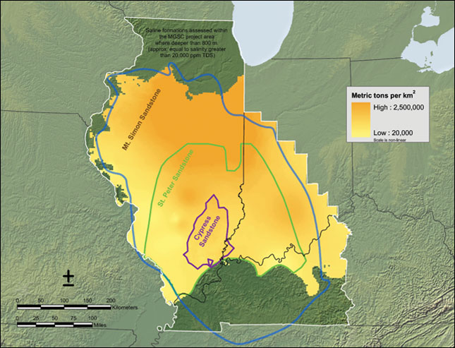
Four saline reservoirs in the Illinois Basin are being studied for CO2 storage potential. These are the Mississippian Cypress Sandstone, the Ordovician St. Peter Sandstone, the Cambro-Ordovician Knox Supergroup, and the Cambrian Mt. Simon Sandstone.
The Cypress Sandstone is the most widespread and prolific petroleum-bearing sandstone in the Illinois Basin; however, areas with thick Cypress tend to have a large water-bearing zone that may be considered a saline storage target. The porous and permeable sandstone can reach a thickness of 200 feet, although it is generally less than 100 feet thick and displays considerable variation in thickness and lateral extent. The Cypress Sandstone is the shallowest of the saline reservoirs assessed, and is found at depths reaching approximately 3,000 feet in parts of the Illinois Basin. Shale beds and a laterally continuous carbonate, the Beech Creek (Barlow) Limestone, form the overlying seal for the Cypress Sandstone.
The St. Peter Sandstone is a widespread, porous and permeable quartz sandstone that is generally fine-grained with good lateral continuity. Seals above the St. Peter include several hundred feet of dense limestone and dolostone overlain by 45.7 to 76.2 m (150 to 250 ft) of Maquoketa Shale.
The Knox Supergroup lies directly under the St. Peter Sandstone and consists of several thousand feet of dolostone and minor sandstone. The Knox is an integrated reservoir and seal interval. Much of the Knox is non-porous dolostone, but scattered throughout are porous and fractured zones (with varying amounts of porosity) that have permeability suitable for injection of CO2. The Knox may be particularly important as a sequestration target in parts of the Illinois basin where the Mt. Simon Sandstone is too deep or absent. Seals above the Knox are the same as for the St. Peter Sandstone — Upper Ordovician carbonates and shales. A multi-state characterization study of the Knox and St. Peter Sandstone is in progress.
The Mt. Simon Sandstone is commonly used for natural gas storage in the northern Illinois Basin. Although water in the upper Mt. Simon is considered suitable for drinking in northernmost Illinois, the formation is brine-filled in the remainder of the state — and no oil or natural gas resources have been discovered in this unit. The Mt. Simon has fair to good permeability and porosity, and the overlying strata contain impermeable limestone, dolomite, and shale intervals. The depth of the Mt. Simon ranges from approximately 610 to 4,267 m (approx. 2,000 to 14,000 ft) below the surface. At its greatest thickness in the Illinois Basin, the Mt. Simon is over 793 m (2,600 ft) thick. While there are no outcroppings in Illinois, correlative units are exposed in southern Wisconsin, southeastern Minnesota, and Missouri. The Mt. Simon exists in the subsurface throughout much of Indiana, Iowa, Michigan, and Ohio. In the southern region of the Basin, the potential CO2 reservoir facies are either very deep or may be absent due to post-depositional erosion, especially towards the southwest.
A GIS-based volumetric methodology was used to quantify the storage resource of the saline formations. For the current study, the 2010 storage efficiency factors were used, and the reservoir area was extended eastward to accurately adjoin the area defined by MRCSP. The total storage resource for the Illinois Basin is estimated to be 12 to 161 billion metric tons (13 to 177 billion tons).
For additional information and more detail see:
World Resources Institute
National Energy Technology Laboratory (NETL)